Amiata, Internal Hills and Metalliferous Hills, Maremma Grossetana, Mountains, Province of Grosseto, Province of Siena
206 Views
Upper between 400,000 and 200,000 years ago. It is located in the southern part of the region, in Maremma, and is visible from a great distance. For example, on clear days, it is clearly visible from the Florentine Chianti which is about 80 km as the crow flies. The mountain rises to 1,738 meters above sea level and is heavily ...
Read More »
Amiata, Internal Hills and Metalliferous Hills, Maremma Grossetana, Province of Grosseto, Villages
134 Views
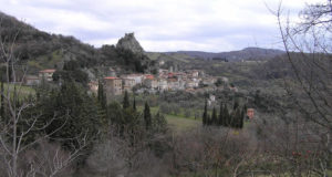
Roccastrada is located in a beautiful position overlooking the Maremma, at an altitude of 475 meters in the Grosseto Metalliferous Hills. The town is located in a panoramic position towards Monte Amiata and the plain of the Ombrone and its tributaries. Roccastrada was since the Middle Ages an important mining center where there were copper and silver mines. AN ANCIENT ...
Read More »
Amiata, Internal Hills and Metalliferous Hills, Castles, towers and fortresses, Maremma Grossetana, Province of Grosseto
291 Views
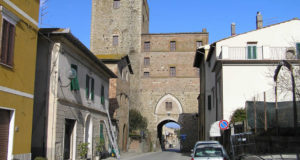
The Castle of Triana is located about 6 km from Roccalbegna in the direction of Monte Amiata. In the past this castle was also called with the names of Triana di Santa Fiora or Atriana. The castle is located at an altitude of 767 m above a rocky knoll to the west of the mountainous buttress which from Monte Labbro ...
Read More »
Amiata, Internal Hills and Metalliferous Hills, Maremma Grossetana, Province of Grosseto, Villages
178 Views
Roccalbegna is a picturesque village located at the confluence of two rivers, the Marlancione and the Albegna, the town is dominated by high overhanging cliffs. Roccalbegna is located at an altitude of 522 metres. The buildings of Roccalbegna are almost all in stone. Among the monuments of interest is the Romanesque parish church of Saints Peter and Paul from the ...
Read More »
Amiata, Internal Hills and Metalliferous Hills, Maremma Grossetana, Province of Grosseto, Villages
301 Views
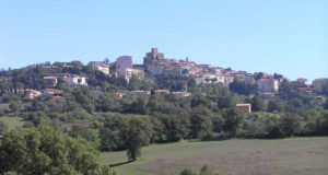
Manciano is located in the center of an area of great archaeological importance, about 60 km from Grosseto, 18 km south-west of Pitigliano and 40 km north-east of Orbetello. The town, located on the top of a hill at an altitude of 444 metres, is dominated by the Rocca Aldobrandesca, today the seat of the municipality. The village of Manciano ...
Read More »
Amiata, Internal Hills and Metalliferous Hills, Maremma Grossetana, Province of Grosseto, Villages
269 Views
A few kilometers from Grosseto is the medieval village of Paganico, located along the Ombrone plain at 63 meters above sea level. In the Middle Ages Paganico was a small center under the control of the Aldobrandeschi, which in the XIII century became part of the possessions of the Republic of Siena. Siena decided in 1262 to erect it as ...
Read More »
Amiata, Internal Hills and Metalliferous Hills, Maremma Grossetana, Province of Grosseto, Villages
142 Views
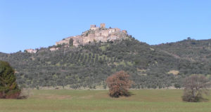
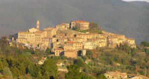
Montemassi is a charming medieval village in the Grosseto Maremma, located in the municipality of Roccastrada along the road that connects Roccastrada to Massa Marittima and Gavorrano, about 15 km from the Giuncarico exit of the Aurelia. The village is located on the slopes of a hill full of olive trees, at an altitude of 280 metres. AN IMPRESSIVE MEDIEVAL ...
Read More »
Amiata, Internal Hills and Metalliferous Hills, Maremma Grossetana, Province of Grosseto, Villages
153 Views
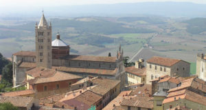
Massa Marittima is a stupendous town full of interesting medieval artistic testimonies. Probably of Etruscan origin, the city preserves many monuments from its most flourishing period, which can be traced back to the mid-9th century when the bishop, up until then resident in Populonia, took office there. The period of maximum splendor of the city is however that between the ...
Read More »
Amiata, Internal Hills and Metalliferous Hills, Maremma Grossetana, Province of Grosseto, Spa, Villages
370 Views
Saturnia is a small town located on a high travertine rock at 294 meters high in the municipality of Manciano. The town is an important spa thanks to the presence of sulphurous water (37.5 ° C) which attracts people every year for sweat cures, muds etc. There are historical documents dating back to the XII century that already speak of ...
Read More »
Amiata, Internal Hills and Metalliferous Hills, Castles, towers and fortresses, Hills, Maremma Grossetana, Province of Grosseto, Villages
799 Views
Pari is a very suggestive small village located between Siena and Grosseto, practically on the border between the two provinces which is marked here by the Farma river valley, a tributary of the Merse. Sometimes, due to its position, the village is also referred to as the place where the Maremma begins, although more often the real Maremma starts from ...
Read More »
 Borghi di Toscana Guida ai borghi e ai paesaggi della Toscana